

Two short street projects in east Maricopa could add a more continuous Seven Ranch Road connection between Porter Road, Whisker Road and the area east of Gunsmoke Road.
The Maricopa Association of Governments’ current transportation program identifies two new two-lane roadway segments:
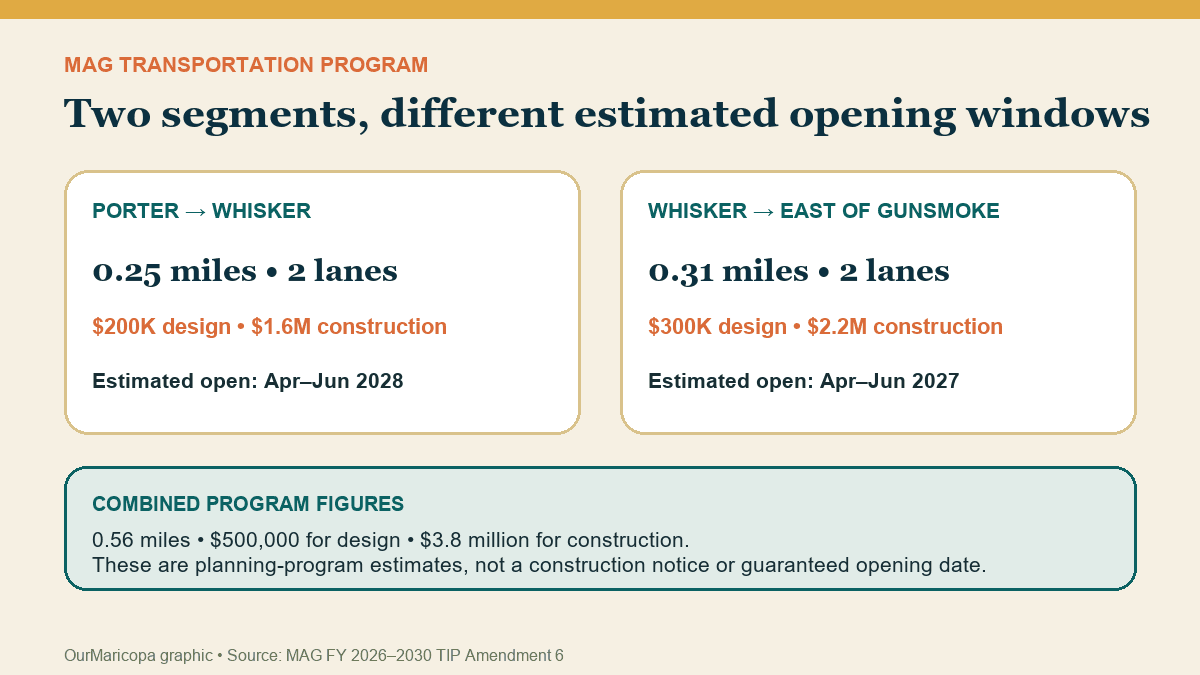
Porter Road to Whisker Road: 0.25 miles, with $200,000 programmed for design and $1.6 million for construction. The document estimates opening between April and June 2028.
Whisker Road to one-quarter mile east of Gunsmoke Road: 0.31 miles, with $300,000 for design and $2.2 million for construction. The estimated opening window is April through June 2027.
Together, the entries describe 0.56 miles of new road, $500,000 in design funding and $3.8 million in construction funding.
Those are regional program figures. They are not a notice that construction has started, and the opening quarters are estimates rather than guaranteed dates.
Where the two segments fit
The western segment runs from Porter Road to Whisker Road. The eastern segment continues from Whisker Road to a point one-quarter mile east of Gunsmoke Road.
Read together, the projects describe a corridor built in pieces rather than one single contract. They also carry different estimated opening windows: the eastern piece appears first in the regional schedule, followed by the connection to Porter.
That sequencing matters for nearby residents. A road can be designed as part of a larger network while individual sections wait on right-of-way, utilities, drainage, procurement or adjacent development.
What a “minor collector” does
MAG classifies both entries as minor collector streets. A collector is intended to gather traffic from local neighborhood streets and connect it to larger roads. It is a smaller role than a major arterial or freeway.
The program lists two through lanes for each Seven Ranch segment. That means residents should picture a local two-lane street connection, not another SR 347.
The practical value is network continuity. As homes, schools and commercial sites are added east of the city’s older core, connected collector streets can provide more direct local routes and reduce the number of short trips that must funnel onto one major roadway.
They do not, by themselves, solve regional commuting congestion. OurMaricopa’s SR 347 commuter guide covers the separate state corridor and traffic resources.
What is funded in the program
For the Porter-to-Whisker segment, the regional document places design in 2026 and construction in 2027. The listed amounts are $200,000 for design and $1.6 million for construction.
For the Whisker-to-east-of-Gunsmoke segment, it also places design in 2026 and construction in 2027, at $300,000 and $2.2 million respectively.
The combined $4.3 million is the sum of the listed design and construction amounts. It should not be treated as a final bid price. Project costs can change as design advances, property needs are resolved and construction is procured.
The dates are targets, not promises
A Transportation Improvement Program is a regional funding and scheduling document. It helps identify when an agency expects work to occur and how it is programmed. It is not the same as a City construction alert.
Before residents should expect barricades or detours, several more concrete signals would normally appear:
Final design and drainage plans.
Completed right-of-way or easement work.
Utility coordination.
A construction procurement or awarded contract.
A notice to proceed.
A City road-work notice with dates and traffic impacts.
If those milestones move, the estimated opening quarter can move too.
Why east-side connectivity matters
The City’s General Plan describes the Seven Ranches area as a large-lot enclave with fragmented parcels and calls for coordinated development. That makes roads, utilities and access especially important: a line on a long-range map only becomes useful when adjoining pieces connect and can be maintained.
The Seven Ranch entries also sit within a larger east-side transportation program. The same MAG amendment lists other Maricopa projects, including future work on Honeycutt Road, Peters and Nall Road, White and Parker Road and Sonoran Desert Parkway. Each has its own scope, budget and schedule.
That broader list reinforces the central point: the Seven Ranch work is one local connection inside a multi-year network buildout.
Residents considering a move can use OurMaricopa’s new resident guide for a broader look at roads, schools, utilities and daily life. A regional program date should never replace a current City notice when planning access to a specific property.
What to watch next
The most useful next evidence would be a City design update or procurement record naming one of the two segments. A final plan set could also answer questions the regional table does not:
Exact intersection geometry.
Sidewalk, bike-lane and drainage features.
Utility and property impacts.
Construction phasing.
Temporary access during the work.
Revised cost and opening date.
Until those records appear, the accurate summary is limited but meaningful: two Seven Ranch Road segments totaling 0.56 miles are programmed as new two-lane streets, with design funding in 2026, construction funding in 2027 and estimated openings in 2027 and 2028.
Sources
Maricopa Association of Governments, “Amendment to the FY 2026–2030 MAG Transportation Improvement Program,” Amendment 6, Table B1, printed April 17, 2026; accessed Oct. 8, 2026: Open source
City of Maricopa, “General Plan Elements,” Seven Ranches character-area and circulation context; accessed Oct. 8, 2026: Open source
Pinal County Assessor, parcel map showing Seven Ranch, Whisker, Gunsmoke and Porter roads; accessed Oct. 8, 2026: Open source