Drivers who use a U-turn to reach a store, school or neighborhood along John Wayne Parkway may need a different route before September ends.
The Maricopa Police Department announced Monday that U-turns will no longer be permitted at most intersections along the parkway beginning in late September. An official City map attached to the notice marks eight locations for new restrictions and three where a no-U-turn restriction already exists.
The announcement does not give an exact installation or enforcement date. Until signs change, drivers should follow the traffic controls posted at each intersection rather than assume the restriction is already active everywhere.
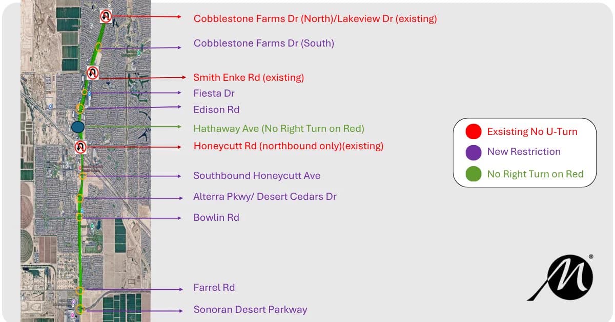
Eight intersections marked for new restrictions
On the official map, purple identifies the new restrictions. From north to south, those locations are:
Cobblestone Farms Drive on the south side of the intersection
Fiesta Drive
Edison Road
Southbound Honeycutt Avenue
Alterra Parkway / Desert Cedars Drive
Bowlin Road
Farrell Road
Sonoran Desert Parkway
Three red labels identify existing no-U-turn restrictions at Cobblestone Farms Drive North / Lakeview Drive, Smith-Enke Road and northbound Honeycutt Road.
Hathaway Avenue is shown separately in green and labeled No Right Turn on Red. The map does not place Hathaway in the purple new-restriction category. Drivers should still rely on the signs facing their lane and direction of travel.
The directional wording matters at Honeycutt. The official map distinguishes the existing northbound Honeycutt Road restriction from a new restriction at southbound Honeycutt Avenue. A quick glance at a general list could miss that detail.
What drivers should do before the signs go up
If a regular route depends on a U-turn at one of the purple locations, use the next few days to identify a legal alternative. That may mean entering a shopping center from another driveway, continuing to a different intersection or approaching a destination from the opposite direction.
Avoid making the adjustment at the last second. John Wayne Parkway carries local traffic, school trips and commuters headed toward SR 347, so a sudden lane change can create another problem while trying to solve the first one.
MPD's announcement says the restrictions will apply at “most intersections,” and the attached map is the clearest official location guide available Tuesday morning. The post does not state whether every direction at each purple intersection will receive the same sign, whether signs will appear all at once or whether an enforcement grace period is planned.
For those details, the sign installed at the intersection will control the movement. Residents can also watch the Maricopa Police Department's official public updates for a more precise effective date.
Keep construction and this traffic change separate
This City traffic-control change is separate from ADOT's active SR 347 construction north of Maricopa. A driver could encounter both on the same trip, but they come from different notices and may change on different schedules.
Before a commute, check OurMaricopa's live SR 347 traffic and camera page and the SR 347 commuter guide. The community calendar can also help when a school event or City gathering changes the time of a local trip.
The practical takeaway is simple: late September will bring a new set of turn rules on John Wayne Parkway. The map tells drivers where to start planning, while the posted signs will tell them exactly what is legal when they reach each intersection.
Sources
Maricopa Police Department — “Traffic Change Coming to John Wayne Parkway.” Official X post and attached City map. Posted Sept. 21, 2026; the public feed displayed “16h” during the Sept. 22 morning review. Accessed Sept. 22, 2026, at approximately 7:15 a.m. Arizona time. Source for the late-September timing and general scope.
City of Maricopa / Maricopa Police Department — John Wayne Parkway restriction map. Second image attached to the official post above. Accessed Sept. 22, 2026. Source for the new, existing and separately labeled intersection restrictions. The map provides no exact installation date.
Cover: Original AI-generated editorial illustration by OurMaricopa; it does not depict a documented scene.